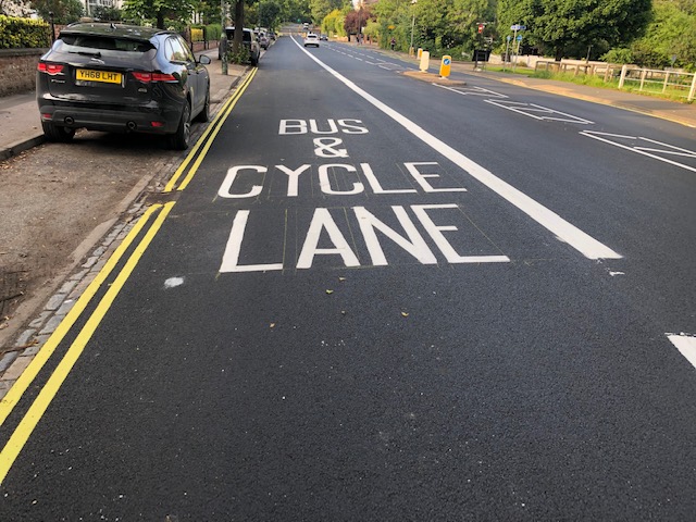
Local councillors have thanked City of York Council and contractors for the smooth running of the resurfacing works along Tadcaster Road.
The works are now complete and reinstatement of road markings are nearing completion. Cycle lanes have been widened to the standard 1.5 metre width along some sections of the road and the previous very narrow ‘filter box’ for vehicles and cycles turning right onto Nelsons Lane has been removed.
The presence of pedestrian refuges acted as a constraint in enabling more sections of cycle lane to be widened, which has led to calls for their replacement with zebra crossings to provide better facilities for pedestrians, slow traffic down and remove pinch points along the road for cycling.
The whole corridor from the Askham Bar Park & Ride site to Micklegate Bar is in need of a review to identify and tackle issues and obstacles that make people less likely to cycle along this route.
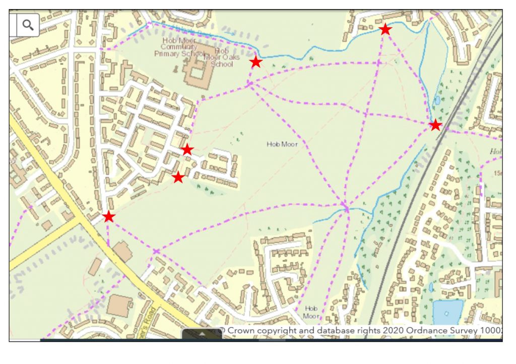
In recent months it has been great to see more people cycling, with many trying new routes. Questions have been raised about the rationale for the current cycle barrier arrangements at some of the entrance points to Hob Moor and how changes might be made which could improve access for bicycles of all types.
Current position
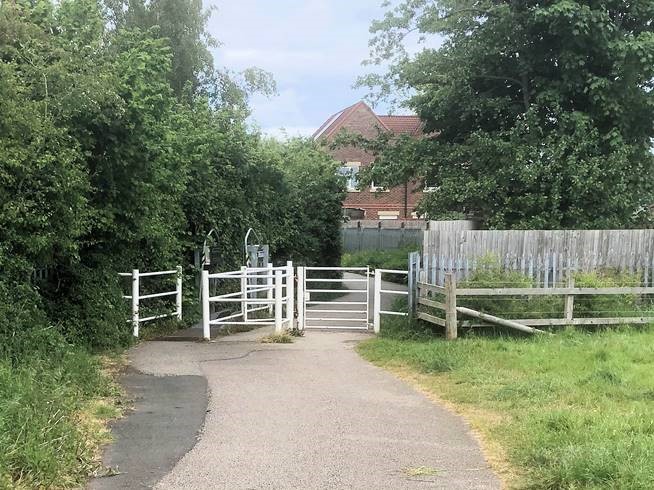
Restricting barriers are in place at the following points on the moor – Railway underpass, Hob Moor Drive, Green Lane, Hob Stone Court (entrance onto the moor heading north), Hob Stone Court (on path from the Kingsway West entrance) and Kingsway West.
The barriers in use at these locations consist of:
a cattle grid leading to a raised ‘chain catcher’ plinth and shoulder-height guards
a kissing gate
a locked swing gate
A RADAR key which opens the swing gate can be purchased from City of York Council at a cost of £3, though on the council and i-Travel York websites there seems to be no explicit mention of the fact that these keys can be used to open these gates.
History
The current barrier arrangements were installed following planning permission being granted in August 2004. The issue was subject to coverage in The Press at that time.
From the information I have been able to gather, the barriers were installed in response to motorbikes using the moor, which was an issue that emerged in the 1990s. This behaviour caused nuisance to the residents whose properties are adjacent to the moor and posed a danger to grazing cattle. I also understand that easy access to the moor on motorbike was used by criminals to evade the Police. It was also considered safer to slow cyclists at the access points to the moor where sight lines are poor and a speeding cyclist could represent a threat to themselves, pedestrians and other cyclists.
There is a recognition by council officers that a review of barrier design across the city is needed, but this has not yet happened.
Analysis
The York Cycle Campaign (YCC) registered their objections to the barriers at the time they were installed. When considering changes to the current arrangements, I believe that views should be sought from a range of individuals and organisations with a legitimate interest, including:
Neighbouring residents
The farmer whose cattle graze the moor
The Police
Friends of Hob Moor
City of York Council planning, transport, ecology and legal officers
Ward councillors for Dringhouses & Woodthorpe, Westfield and Holgate wards
YCC and other cycling and access groups, eg Cycling UK York branch
It would be helpful to understand whether the threat posed by inappropriate use of motorbikes remains as great as when the barriers were installed. It would also be good to better understand from YCC members and access groups why the RADAR key option for securing access to the moor may not be a viable option. Is it due to the difficulty in getting hold of a key, or a (not unreasonable) wish to have barrier-free access without having to plan ahead for every trip?
There are a range of possible options, set out below. This is not an exhaustive list and some could be considered in conjunction.
Remove the plinths and shoulder-height guards
Pros – would facilitate easier access to the moor for more types of bicycles / trailers
Cons – would allow motorbikes onto the moor, may not allow sufficient width for some bicycles / trailers that would still need to use the swing gate, may require planning permission
Remove just the plinths
Pros – would facilitate easier access to the moor for bicycles, could be used as a ‘trial’ to see if the shoulder guards alone act as a deterrent for motorbikes
Cons – May allow motorbikes onto the moor, may not allow sufficient width for some bicycles / trailers that would still need to use the swing gate, may require planning permission
Promote awareness of the option to obtain a RADAR key and make it easier to obtain one
Pros – if successful, could make access to the moor more inclusive
Cons – does not facilitate easy access without forward planning
Replace the RADAR key with a technological solution, eg users are issued with a fob which triggers the gate to open when they ‘touch in’ and closes behind them
Pros – if successful, could make access to the moor more inclusive and may not require cyclists to dismount to open the gate with a key
Cons – possibly expensive, no ‘off the shelf’ product immediately available, would require maintenance, does not facilitate easy access without forward planning
Do nothing
Pros – it continues to be very difficult for motorbikes to access the moor
Cons – the current barrier arrangements continue to pose an awkward obstacle for many cyclists and do not permit access to the moor for non-standard bicycles or trailers which can only gain access via use of a RADAR key to open the swing gates
Next steps
A number of possible actions arise which may help to gather information to inform recommendations and decisions going forward.
Ask the Police whether the threat posed by inappropriate use of motorbikes remains as great as when the barriers were installed
Ask Dringhouses & Woodthorpe, Westfield and Holgate ward councillors whether their local knowledge indicates if the threat posed by inappropriate use of motorbikes remains as great as when the barriers were installed
Ask neighbouring residents for their views
Ask YCC and other cycling and access groups for their views
Ask council planning, transport and legal officers whether planning permission would be needed for any alterations to be made to the current barrier arrangements
Ask the council transport team about the likelihood of a city-wide review of barrier types starting sometime soon, and what residents can do to help, eg mapping barriers
Ask the council’s Ecology officer what issues, if any, have been encountered in recent years in relation to damage to habitat on the moor caused by motorbike incursions
Ask the farmer what issues, if any, have been encountered over recent years in relation to motorbike-related anti-social behaviour and the welfare of the cattle
Ask Friends of Hob Moor for their views
Explore options for a technological replacement for the RADAR keys
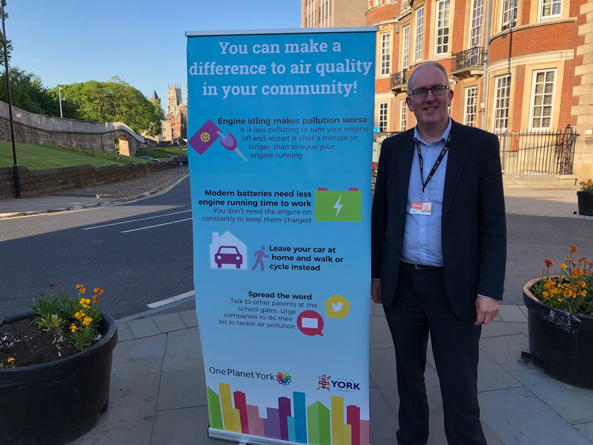
It’s Clean Air Day, which is an opportunity to find out more about air pollution, share information with friends and colleagues, and help make the air cleaner and healthier for everyone. There is information and resources available at https://www.cleanairday.org.uk/
Local Lib Dem councillor Stephen Fenton said “Clean Air Day is a chance for us to focus on what more needs to be done to encourage cycling and walking in York. Better air quality is key to that, as are improvements to cycle lanes, both on and off road.”
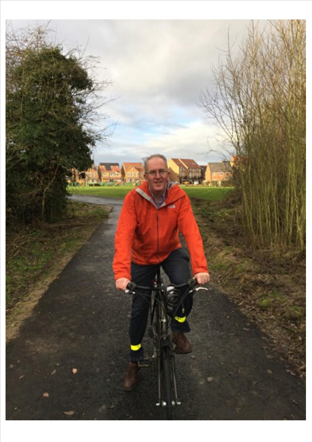
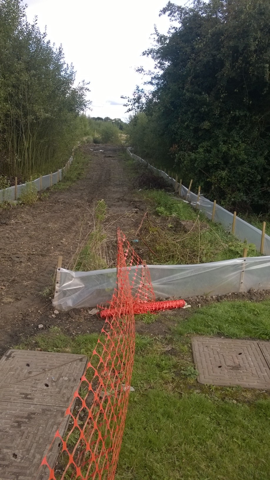
Progress is being made with the construction of the long-awaited cycle path linking the Revival estate (on the old College site) with the green lane path. The new path, which will run alongside the College playing fields, will provide residents with quicker and safer access to Bishopthorpe and the Knavesmire.
Nearly there!
Construction of the path could not begin until the local newt population had been trapped and relocated.
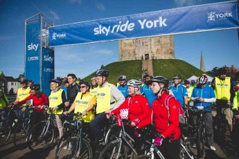
The York Council has announced that on Sunday 13 September 2015 Sky Ride York will take to the city’s historic streets in partnership with British Cycling.
Due to the size and scale of the event there will be a number of temporary traffic and transport changes to ensure the safety of everyone taking part.
The traffic free route has been extended for 2015 to allow residents and visitors to see more of York whilst taking in some of the city’s most historic landmarks such as Clifford’s Tower and The Minster.
The 7km route starts at Clifford’s Tower and will see cyclists head up Castlegate and Coppergate before joining onto Pavement and passing York’s most famous street, The Shambles.
Riders will then turn left onto Colliergate and briefly see King’s Square before turning right onto St Andrewgate. They will then head onto Aldwark, Goodramgate, and Deansgate when York Minster will come into view. Riders will then head across the Minster Piazza and onto Duncombe Place before passing over Lendal Bridge onto Leeman Road.
The route will then see cyclists turn right past Memorial Gardens and along Wellington Row, Skeldergate and Terry Avenue where they will follow the Ouse until Rowntree Park.
Cyclists will then head along Butcher Terrace and turn left onto Bishopthorpe Road before turning left on the cycle path to bring them back down to the river and over Millennium Bridge. They will then follow the riverside cycle path back to Clifford’s Tower.
Traffic and Travel
The Sky Ride York route will be closed to all traffic from 10.30am until approximately 5pm, or as soon as possible after the event has finished to ensure the safety of everyone taking part. The inner ring road will be closed at Lendal Bridge for general traffic for the duration of the ride.
Residents and visitors are urged to make use of the city’s extensive Park&Ride network on the day, particularly by using the Park&Pedal facilities at any of York’s six Park&Ride sites.
Bus travel
Bus routes will be altered to ensure that access into and out of the city centre is maintained, whilst avoiding those roads closed as part of the route. Revised timetables will be put into place to ensure the smooth running of bus services. Residents and visitors are being encouraged to check their travel plans in advance and allow extra time for their journeys on the day. A complete list of bus route diversions will be available to download from:http://www.itravelyork.info/events/sky-ride-york-2015
Car Parks
Castle car park will continue to be open on the day, however there will be reduced capacity to allow for one of the Sky Ride ‘activation zones’ featuring activities for residents and visitors to enjoy. A traffic management stop/go process will be in place here to assist the smooth flow of traffic. Esplanande car park will also be open and will have a traffic management stop/go system in place. St George’s Field car park will be open but will have a reduced amount of spaces during the day.
Rowntree Park car park will be closed on both Saturday 12 and Sunday 13 September due to the Festival of Cycling taking place, as in previous years. For safety reasons there will be no access to parking inside the route.
For more information on Sky Ride York, or to register for the ride visit www.goskyride.com/York
City of York Council is encouraging residents to dust off their bikes this summer and register for Sky Ride York, a traffic free bike ride for all abilities on Sunday 13 September.
City of York Council is encouraging residents to dust off their bikes this summer and register for Sky Ride York, a traffic free bike ride for all abilities on Sunday 13 September.
A circular route taking in some of York’s most historic landmarks, including The Minster and Clifford’s Tower, will be closed to traffic between 10.30am – 4pm, allowing cyclists of all ages and abilities the chance to celebrate cycling on traffic-free streets.
The route will also take in the York Festival of Cycling in Rowntree Park where riders will be able to stop off and take a look around. There’s something for everyone with have-a-go sessions, an AirBag for BMXers to try tricks on and professional cyclists will also be giving a breathtaking display in stunt cycling.
Spin class
Cllr Nigel Ayre, Executive Member for Leisure, Culture and Tourism, said: “Sky Ride York gives residents and visitors the rare chance to ride a stunning traffic free route around York. After the amazing turnout of over 10,000 people in 2014 I hope even more people will get on their bikes and come along to Sky Ride York.”
Residents who want to hone their cycling skills ahead of the event can also register to join a Sky Ride Local bike ride, with many different rides taking place. There are rides to suit all abilities with steady rides from 7 miles up to challenging 30 mile rides. For more information visit http://www.goskyride.com/york (more…)
A new, Inclusive Cycling Club is launching in York which will allow disabled residents who would like to enjoy cycling on specialised bicycles to take up this popular activity.
The club sessions, organised by City of York Council, will take place at York Sports Village and start on Thursday 9 April from 2pm to 4pm. The sessions are suitable for young people and adults over the age of 11 years and will continue three times a week at the following times:
Wednesdays from 5pm to 6.30pm
Thursdays from 2pm to 4pm
Sundays from 3pm to 5pm
A range of different specialised bikes will be on hand to enjoy, including three wheeled bicycles and ‘steer from the rear’ tandems which help improve balance and cycling confidence. Flat bed bikes with platforms for wheelchairs at the front, mountain bikes and road bikes will also be available. The new club welcomes the support of local cycling organisations Get Cycling and Open Country, who are bringing additional bikes and with a fleet of 30 cycles available to the club everyone attending will be able to have a go.
This new Inclusive Cycling Club is one of the ways in which the council is working to reduce health inequalities in the city, help improve physical and mental health and provide financially sustainable health and wellbeing opportunities for everybody across the city.
The cost for club sessions is £5 per hour (free for carers), payable on the day at the Sports Centre Reception.
In the wake of decisions in London Labour Councillors in York are now advocating, on social media, the introduction of a default 20 mph speed limit across the whole of York.
Labour were accused of sneaking through their proposed “wide area” 20 mph limits when voters last went to the polls in 2011. Their plan was in the small print of a manifesto with most residents never saw.
The scheme in London is apparently aimed at “reducing cycling casualties”. Ironically a previous study in the capitalrevealed that the introduction of 20 mph limits there had resulted in an increase in average speeds.
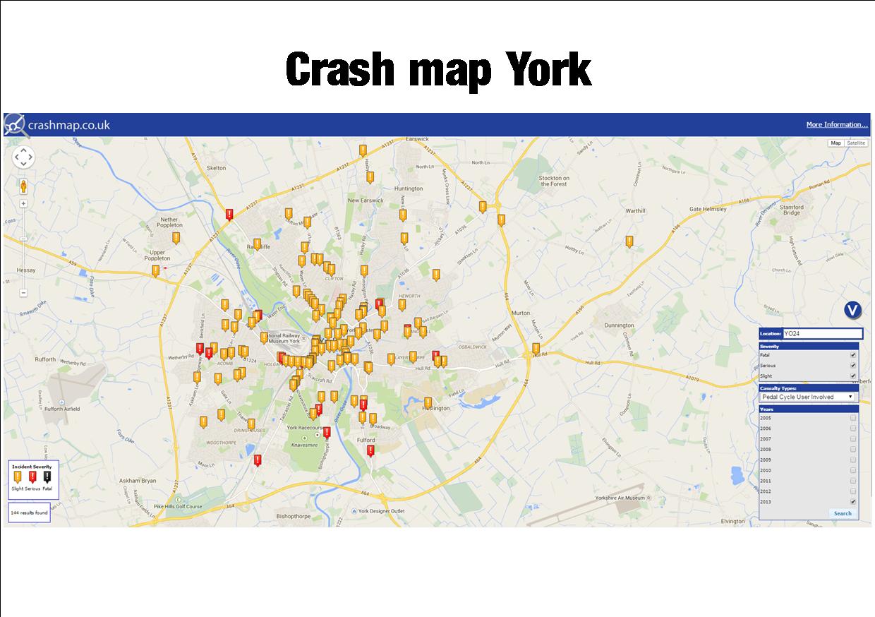
In York, most cycling accidents in result in slight injuries, occur on roads where vehicle speeds are already low and often at road junctions (click for map). Accident levels have reduced in recent years to a total of 144 in 2013 (the last full year for which figures are available) following the introduction of more “off road” cycle tracks. There were no fatalities.
Cycling was 61% safer in 2012 than it was in 2002 (per mile travelled) according to the CTC.
Labour has spent £600,000 on implementing “wide area” 20 mph limits since 2012.
Out of the 535km of roads within York’s Outer Ring Road / A64.
333km (62%) of road are subject to a 20mph limit.
202km (38%) have a speed limit of 30mph or more.
Of the 333km of roads with a 20mph limit, 275km (51% of the total) have been created as 20mph ‘signed only’ limits during the last 3 years.
Prior to this the majority of 20mph limits were traffic calmed 20mph Zones.
The council has refused FOI requests to provide information on “before and after” accident rates on the “signed only” streets in west York or to provide information on the actual effect – if any – that the signs have had on driver speeds.
It is to be hoped that all candidates contesting the Council elections on May 7th will make their policies clear on how cycling can be encouraged and made safer.
In addition electors need to know which Party’s will extend 20 mph limits and which would focus resources at accident black-spots.