Revised proposals published for Tadcaster Road cycling / walking scheme

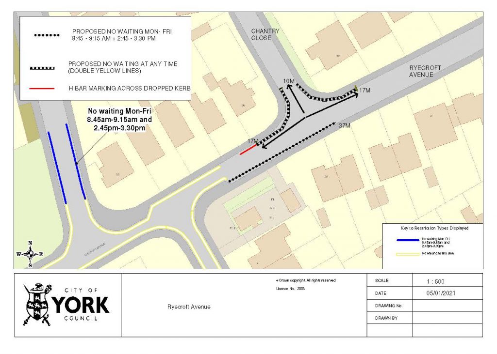
Further details of measures designed to support cycling, walking and bus use along the Tadcaster Road corridor have been published, with feedback invited by 27th June.

After a previous round of engagement in August and September 2021, council officers committed to engage further, in particular with residents in the Slingsby Grove area, on the finer details of the measures proposed for that section of the corridor including a new signalised pedestrian crossing. Letters have been sent to households in that area, and the full suite of information is available online at  www.yourvoice.westyorks-ca.gov.uk/tadcasterroad There will also be a presentation at the Dringhouses & Woodthorpe Ward Committee meeting on 23 June at St Edwards Church.

The proposals being consulted on include:

  • reducing the existing number of parking spaces by two (one on either side of Tadcaster Road, north of Slingsby Grove), leaving a total of nine spaces (five on the Slingsby Grove side and four on the racecourse side)
  • a new location for the pedestrian crossing to provide a safe place for people who park in the southbound layby, and for residents who live in the Hunters Way estate, to get to the shops, bus stop and beyond
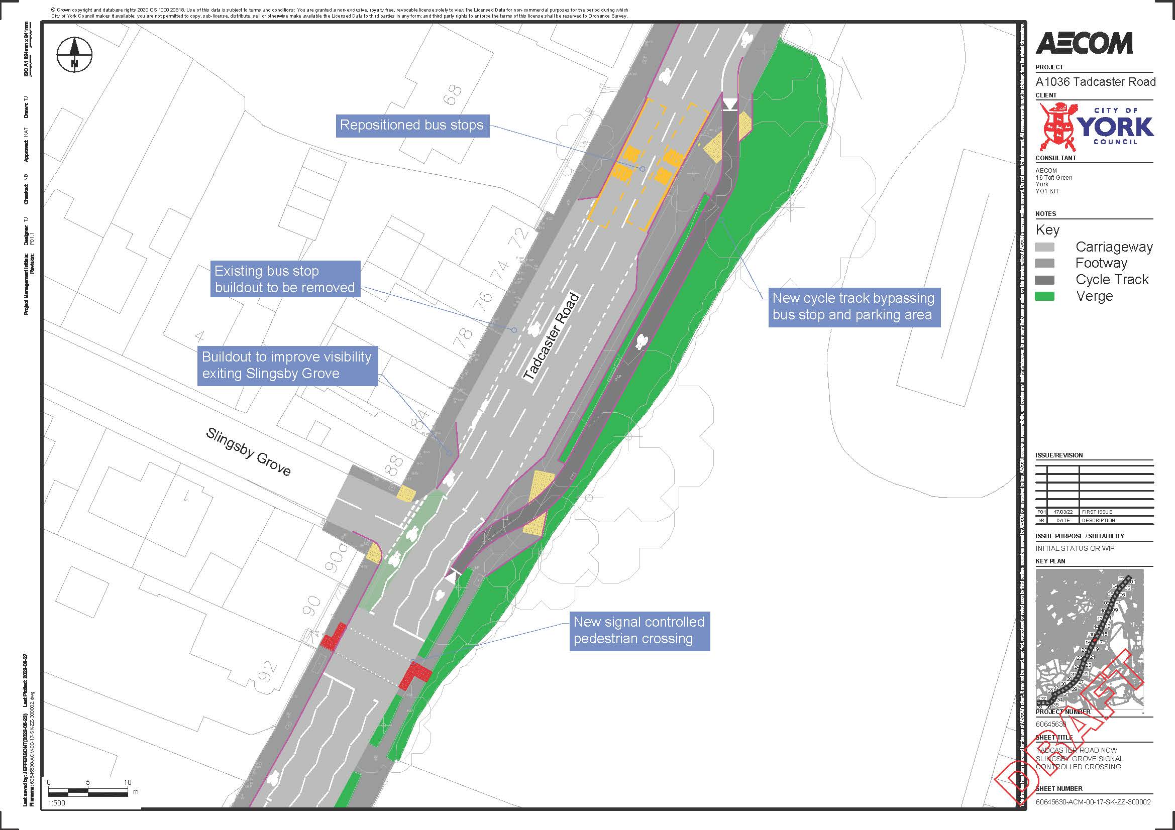
  • a stepped cycle track between The Horseshoe and Slingsby Grove. The cycle way would be higher than the road but lower than the footway, and is divided by a kerb, providing some protection for people cycling from motorised traffic

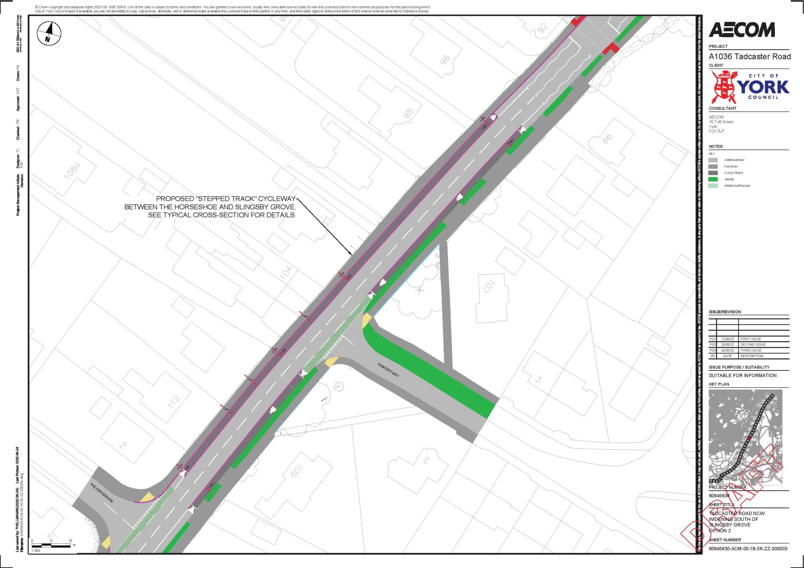
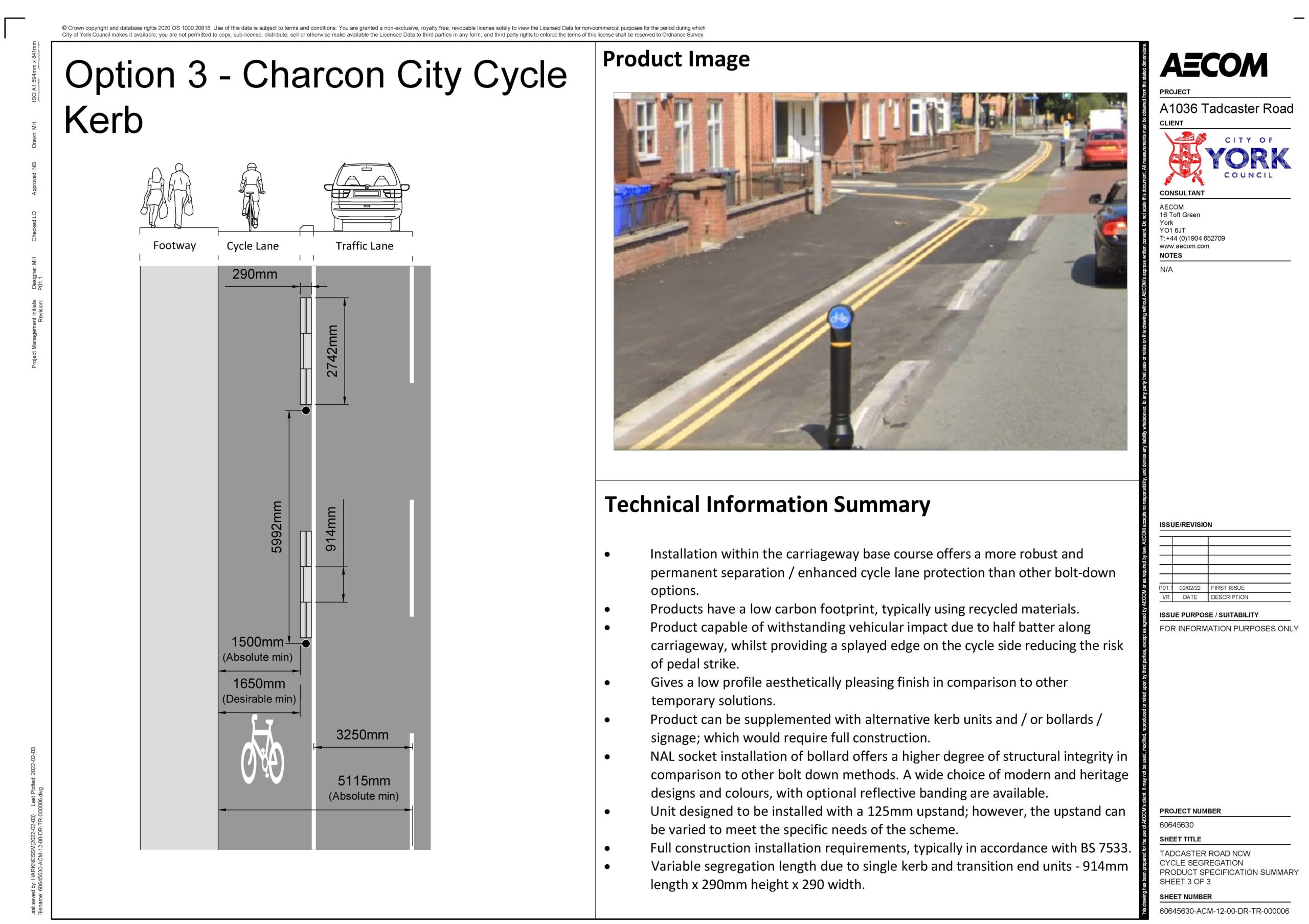
new cycle lane bollards at strategic locations along the route. These highly visible plastic bollards will clearly indicate the cycle lane, to help provide additional protection to people cycling from motorised traffic. The cycle lanes will also be surfaced green, across the mouth of side roads, to highlight their presence to other road users

The proposed works will be funded by £1.4m from the West Yorkshire Combined Authority. This is money that cannot be spent on general highway maintenance.

Consultation launched on parking restrictions

City of York Council has advertised proposals to install parking restrictions at a number of locations around Dringhouses & Woodthorpe ward.

Objections or other representations should be submitted in writing to the Director of Economy & Place to arrive no later than 12th November 2021, by e-mail to highway.regulation@york.gov.uk or by post to Network Management, West Offices, Station Rise, York, YO1 6GA.

Anyone can submit a request to the council for parking restrictions to be implemented. Officers consider all of the requests received and a report then goes to a public meeting (Executive Member for Transport Decision Session) at which it is agreed which proposals can go forward to be advertised.

Moorcroft Road

Burns Court

Chalfonts

The Square

Residents have their say on Tadcaster Road proposals

On Saturday 18 September Dringhouses & Woodthorpe ward councillors held two drop-in sessions for residents to have their say about proposed cycle, walking and bus improvements along the Tadcaster Road corridor, as part of a consultation which closed on 19 September.

Ward councillors were also joined by a member of the council’s iTravel team

The morning session was held on Little Hob Moor and the afternoon session on Hunters Way. Set out below is the feedback received from residents who wrote their comments on post-it notes and stuck them onto the relevant maps.

A1 – The Mount near Dalton Terrace

Afternoon session:

  • Priority for cyclists at outbound junctions with Mill Mount Court and Mill Mount
  • The current off-road provision outbound is difficult to use, many cyclists use the road

A2 – Mount Vale to near Knavesmire Road

Morning session:

  • Existing segregated cycle / foot path should be retained in its current layout – don’t remove the white line
  • All pedestrian crossings should be on raised platforms to slow traffic
  • Concern that having too many crossing points will worsen traffic congestion and air pollution, which affects cyclists and pedestrians
  • Oppose removal of Trentholme Drive filter lane
  • Removal of sections of bus lane on The Mount is pointless and unsafe
  • Oppose loss of central areas which provide safe space for right-turning cyclists
  • Please add traffic lights back to the bus lane at the top of The Mount as congestion is awful with taxis rather than buses halting traffic
  • Need yellow lines on Knavesmire Road

Afternoon session:

  • Protected cycle lane needed inbound from St Georges Place

A3 – Tadcaster Road near Pulleyn Drive

Morning session:

  • For Pulleyn Drive, and for Nelsons Lane, please reinstate the central area for outbound right-turning cyclists – move kerbs back to allow
  • Cycle path from Knavesmire Road outbound should be two-way
  • Need to educate road-users on why the changes have been made and the benefits
  • Clear signage to indicate where paths are shared use
  • All good for me

Afternoon session:

  • Fill in potholes in existing cycle paths
  • Keep cycle lane around the corner from Knavesmire Road onto Tadcaster Road
  • Why not create an off-road cycle path on the inbound side of the road?
  • Happy with shared used proposal, just like Sustrans routes which are shared with no markings
  • No segregation will put pedestrians at risk from ‘racing’ cyclists
  • Could northbound and southbound cyclists be segregated?

A4 – Tadcaster Road near Nelsons Lane

Morning session:

  • Will proposed new pedestrian crossing be a toucan?
  • Need right-turn box for outbound cyclists turning into Nelsons Lane
  • Maintain cycle /pedestrian segregation markings on ‘shared’ path
  • Not enough space for two-way cycle and walking
  • Nelsons Lane crossing is a great idea
  • Refresh off-road cycle markings

Afternoon session:

  • Will there be access points onto the proposed extended shared cycle / foot path for cyclists joining from the streets opposite, eg Chalfonts, Nelsons Lane
  • Will the new shared path be two-way for cyclists?
  • Could the new path be for cyclists only?
  • Pavements could be made more fit for purpose by cutting back vegetation

A5 – Tadcaster Road near St Helens Road

Morning session:

  • Move bus stop on St Helens Road further away from the junction
  • ‘Bypass’ for bikes outside St Edwards church for bikes to continue outbound when lights on red?
  • Need decent-width off-road cycle lane all the way along the route. Inconsistent, patchy cycle route will not tempt drivers to cycle

Afternoon session:

  • Pedestrians and cyclists need to be segregated on the proposed new path from the Tyburn to the Marriott
  • Widening the footway will encroach onto the Knavesmire. Has this been discussed and agreed with the council’s Ecology team? Does it set a precedent? The land on the other side of the fence drops down quite a bit – has this been factored in, eg have civil engineers been consulted?
  • Microprocessor Optimised Vehicle Actuation (MOVA) at the St Helens Road junction will cause more traffic hold-ups

A6 – Tadcaster Road near Slingsby Grove

Morning session:

  • At Royal Chase junction need central space for right-turning cyclists
  • Moving the bus stop would mean access to driveways at 96 & 98 Tadcaster Road would be blocked
  • Encourage school families to use the St Helens Road crossing rather than the refuge near the Fox & Roman pub

Afternoon session:

  • Multiple residents very unhappy about the proposal to relocate the bus stop to the end of their driveways (these driveways serve 3 or 4 houses set back from the road)
  • Proposed new bus stop location would be too near to the existing bus stop at the end of The Horseshoe
  • The bus stop in its current location is well-used by residents of the Royal Chase estate – leave it where it is
  • Need to think strategically about bus stop and pedestrian crossing locations in this area. Is this stop needed?  Could it be relocated further up, eg nearer the library?
  • Suggestion of a cycle lane inside the parking bays at the shops and the library
  • Why remove the trees?
  • What happens to the (Grade II listed) Pinfold?
  • The proposed short stretch of off-road cycle path behind the parking layby on the east side of Tadcaster Road will destroy green space
  • Support for the proposed cycle path behind the layby, will make it safer for cyclists
  • Whatever the outcome with the bus stop, the build-out at the junction with Slingsby Grove needs to be extended to push parking away from that junction and improve sight lines for motorists turning right out of Slingsby Grove
  • Layby and bus stop in front of the shops is a death trap – do we need a stop here so close to the stop at The Horseshoe?
  • Take bike path onto the pavement inbound – enough room for a segregated path
  • Introduce 2-hour parking limit outside shops

A7 – Tadcaster Road near The Horseshoe

Morning session:

  • Oppose removing central / hatching – safe space for right-turning cyclists
  • Retain verge width
  • Tree roots make pavement uneven near here
  • Do we need a new signalised crossing here? Maybe consider a zebra crossing or perhaps a refuge
  • Consider 20mph limit

Afternoon session:

  • Divert footpath away from the road at the Hunters Way junction to improve sight lines for motorists and cyclists pulling out onto Tadcaster Road
  • A signalised crossing here will help pedestrians and also reduce traffic speeds
  • A signalised crossing is not required here, will lead to more stationary traffic. A refuge is fine. What are the footfall stats in support of a signalised crossing?
  • The footpath width is fine as it is
  • Don’t remove right-turn filter lane for Middlethorpe Grove – useful for cyclists as well as motorists
  • Cyclists don’t just cycle in and out of town – they cycle into and out of streets off, and this needs to be factored into the thinking

A8 – Tadcaster Road near Moor Lane roundabout

Morning session:

  • An option to stay on the road for cyclists should be included and visible to drivers as not all cyclists will want to use the path
  • Are the proposed changes to the footpath / cycle path arrangements between the Moor Lane roundabout and York College really needed?
  • Move the Old Moor Lane bus stop further up Tadcaster Road
  • Other parts of the city would benefit more from cycling infrastructure improvements
  • Need to widen the segregated cycle path where Moor Lane turns left onto Tadcaster Road – blind corner and overhanging hedge
  • Do we need to remove trees from the verge in the area around the bus stop opposite York College?

Afternoon session:

  • Direct students to use the pedestrian crossing near to Yorkcraft, rather than the crossing at the College
  • More significant intervention needed at the Moor Lane roundabout to improve traffic flow and in particular to support better bus reliability

A9 – Tadcaster Road near York College

Morning session:

  • Support for widening shared cycle / foot path at ‘cemetery corner’
  • An underpass (or footbridge) for York College should be a priority. Could the existing underpass to the solar system cycle path be adapted / extended?
  • Could cycles use the Park & Ride road through to Tesco?
  • Could the Park & Ride site become a bus interchange, which would allow the bus stops on that section of Tadcaster Road to be removed
  • Need hatching on Tadcaster Road at the top of Sim Balk Lane to stop people coming from the A64 blocking the road
  • This is just an enhanced version of the current poor layout
  • How about a two-way off-road cycle lane on the racecourse side?
  • The scheme continues to put cars first

Afternoon session:

  • If trees are to be removed, new trees should be planted
  • Put the existing pedestrian crossing at York College on a speed table and make that area a 20mph zone
  • Ask Tesco to set up a small shop on the campus site to help reduce the footfall across Tadcaster Road
  • Need a pedestrian crossing at the top of Sim Balk Lane – currently no provision there
  • Support proposal for bus layby opposite York College
  • Oppose proposal for bus layby as it will delay buses
  • Close the ramp leading down to Tesco

Comments not specific to specific elements of the scheme

  • More frequent bus services would encourage greater usage
  • Scheme needs to be designed by urban design specialists, not traffic engineers
  • Look at good examples elsewhere, eg Denmark, Netherlands
  • Need a city-wide strategy, reduce space for cars if necessary, and be brave
  • Action is needed to tackle cyclists who go through red lights or cycle on footpaths. A lot of anti-cycle sentiment (a fair bit of which we heard at the drop-in sessions) stems from the perception that many cyclists flout highway rules and endanger pedestrians with no consequences

Council consults on proposed parking restrictions

City of York Council is consulting on proposals to install double yellow lines and waiting restrictions at a number of locations around Dringhouses & Woodthorpe ward.

Residents wishing to comment on the proposals should e-mail highway.regulation@york.gov.uk no later than Friday 14th May.

Local councillors have been informed that in the coming months there will be consultation on proposed parking restrictions suggested by residents at other locations.

Chantry Close, on both sides, between the projected northern kerbline of Ryecroft Avenue and a point 10 metres north of the said line. Ryecroft Avenue, on its north side, between points 17 metres south west and 17 metres north east from the projected centreline of Chantry Close.

Introducing ‘No Waiting from 8.45am-9.15am and 2.45pm-3.30pm Monday to Friday’ restrictions in Ryecroft Avenue on its south side, between points 17 metres Lane (terminal point of existing ‘No Waiting at any time’ restrictions) and 54 metres north east from the projected centreline of Summerfield Road.

Jervis Road, on both sides, from the projected south eastern kerbline of North Lane south west for 10 metres, and both sides, from the projected north eastern kerbline of Thanet Road north east for 13 metres. Thanet Road, on its north side, between the projected eastern property boundary line of No. 12 Ebor Court and a point 30 metres north west of the said line.

Lovel House access road, on both sides, from the projected north western kerbline of Wains Road north west for 8 metres. Wains Road, on its north west side, between points 15 metres south west and 22 metres north east from the projected centreline of Lovel House access road.

North Lane, on its north side, between points 15 metres west and 20 metres east from the projected centreline of Orchard Way, south side, between points 10 metres north west and 10 metres south east from the projected centreline of Jervis Road. Orchard Way, on both sides, between the projected northern kerbline of North Lane and a point 12 metres north of the said line.

West Thorpe on its north side, between points 10 metres (terminal point of existing ‘No Waiting at any time restrictions’) and 32 metres east from the projected eastern kerbline of Chaloners Road and south side, between points 10 metres (terminal point of existing ‘No Waiting at any time restrictions’) and 16 metres east from the projected eastern kerbline of Chaloners Road.

Council consults on ‘dropped crossing’ policy

City of York Council is consulting residents on changes to its dropped vehicle crossing policy.

City of York Council, as the local highway authority and under Section 184 of the Highways Act 1980, has the power to grant permission for a vehicle crossing to be constructed, enabling a motorised vehicle to drive over a kerbed footway or verge.

Standard dimensions, as set out in Appendix 19 of the council’s
Highways Design Guide

This draft vehicle crossing policy aims to support officer decision making when considering applications for new and improved vehicle crossings. See details of the current process for dropped kerbs applications.

Feedback received through the consultation will then be analysed and a report assessing options and making recommendations for a final policy will be presented to the Executive Member for Transport.

Consultation responses should be sent to streetworks@york.gov.uk before 28 April 2021.

For the past 18 months, Dringhouses & Woodthorpe ward councillors have been working with council officers to try to progress a scheme for dropped crossings to be installed at a number of council-owned properties in the Thanet Road area. Progress is proving to be painfully slow (not helped by Covid), but we continue to push for action to improve road safety.

Have your say on pavement parking

Residents are being encouraged to have their say on pavement parking as part of a Government consultation.

Local councillors increasingly receive complaints from residents who find themselves having to walk in the road due to vehicles being parked on the footpath unnecessarily. This is a particular problem for anyone pushing a pram or buggy, for wheelchair users and for people who are blind or partially sighted.

No way through

The Government consultation on pavement parking is open until 22 November, and details can be found HERE

In summary, the Government wants to gauge the degree of support for ongoing work to improve the Traffic Regulation Order process as a means to tackle pavement parking where it is a problem. It is also inviting views on alternative approaches, with two specific options outlined. These are:

  • legislative change to allow local authorities with civil parking enforcement (CPE) powers to enforce against ‘unnecessary obstruction of the pavement’, or;
  • legislative change to introduce a London-style pavement parking prohibition throughout England.

The Government is also inviting any alternative proposals for managing pavement parking.

A mobility scooter would struggle to get past this van

There are existing statutes and regulations which allow proceedings to be brought by the Police under criminal law for situations where parking on the pavement, in such a way as to cause obstruction, is deemed to be avoidable. These include section 137 of the Highways Act 1980, as amended; for wilfully obstructing the free passage along a highway. Local authorities are currently unable to enforce against obstruction using their civil parking enforcement powers.

Issues at Moorcroft Road shops

Local councillors are lobbying the owner and leaseholder of the land around the Moorcroft Road shops to make some much-needed improvements.

The potholes in the car park at the rear of the shops are getting deeper and pose a real hazard to pedestrians, particularly during wet weather.

Residents have expressed concerns about uneven and rocking paving stones in the area outside the Dick Turpin pub, and the latest problem emerged on 25 September when high winds caused a number of branches to fall from the pine tree, with some others hanging precariously.

A resident has kindly put up some tape to secure the area. Cllr Stephen Fenton has contacted the landowner and leaseholder to request that they arrange an urgent inspection of the tree and for the hanging branches to be removed.

Stephen hopes to meet on site with the landowner and leaseholder in early October.

Event to get views from blue badge holders

City of York Council would like to hear from any blue badge holders and less mobile people who have been affected by the increased pedestrianisation in York city centre.

Join the online workshop on Wednesday 23 September 2-4pm to explore:

– the challenges (what works / doesn’t work)

– understand the range of people’s needs

– ideas for improvements around accessibility and footstreets

Sign up at https://footstreetsworkshop.eventbrite.co.uk

If you are unable to join the workshop then you can complete an online survey at www.york.gov.uk/OBCAccess by 28 September or you can find a paper survey in the September edition of the council’s ‘Our City’ publication.

Former Park & Ride site set for Flu vaccination role

Signs have been erected at the former Askham Bar Park & Ride site announcing that it will close on 24 September and will then be used by the NHS as a ‘mass flu vaccination site.’

Coming soon to Askham Bar

Cllr Stephen Fenton noticed on 17 September that signs had gone up and that the car park had benefited from a deep clean. A worker on site said that he had spent four days doing a thorough litter pick and cutting back vegetation which had taken over many of the parking bays.

Deep cleaned car park

Stephen has asked for clarification on how the site will operate, as it currently serves as a cut-through for residents going to and from the Tesco store.

It is understood that the site is being mobilised to create additional vaccination capacity on the back of the announcement that, in addition to the normal flu vaccination programme, 50 to 64-year-olds who do not have a health condition putting them at risk of the flu will also be eligible for a free flu vaccine. 

Since its transformation from a Park & Ride site into a £4 per day City of York Council Pay & Display car park, the site has been very little used. It was often strewn with litter, which volunteers tried to keep on top of, and was the venue for some late evening ‘boy racer’ meet-ups.

In the draft Local Plan the site is earmarked for housing.

Latest planning applications for Dringhouses and Woodthorpe Ward

Below are the latest planning applications received by the York Council for the Dringhouses and Woodthorpe ward.

Full details can be found by clicking the application reference

—–

15 Wordsworth Crescent York YO24 2RX

Two storey side extension

Ref. No: 20/01503/FUL 

——-

14 Nevis Way York YO24 2XF

Single storey side extension

Ref. No: 20/01482/FUL 

—-

Representations can be made in favour of, or in objection to, any application via the Planning online web site.  http://planningaccess.york.gov.uk/online-applications/

The Council now no longer routinely consults neighbours by letter when an application is received