Further details of measures designed to support cycling, walking and bus use along the Tadcaster Road corridor have been published, with feedback invited by 27th June.
After a previous round of engagement in August and September 2021, council officers committed to engage further, in particular with residents in the Slingsby Grove area, on the finer details of the measures proposed for that section of the corridor including a new signalised pedestrian crossing. Letters have been sent to households in that area, and the full suite of information is available online at www.yourvoice.westyorks-ca.gov.uk/tadcasterroad There will also be a presentation at the Dringhouses & Woodthorpe Ward Committee meeting on 23 June at St Edwards Church.
The proposals being consulted on include:
reducing the existing number of parking spaces by two (one on either side of Tadcaster Road, north of Slingsby Grove), leaving a total of nine spaces (five on the Slingsby Grove side and four on the racecourse side)
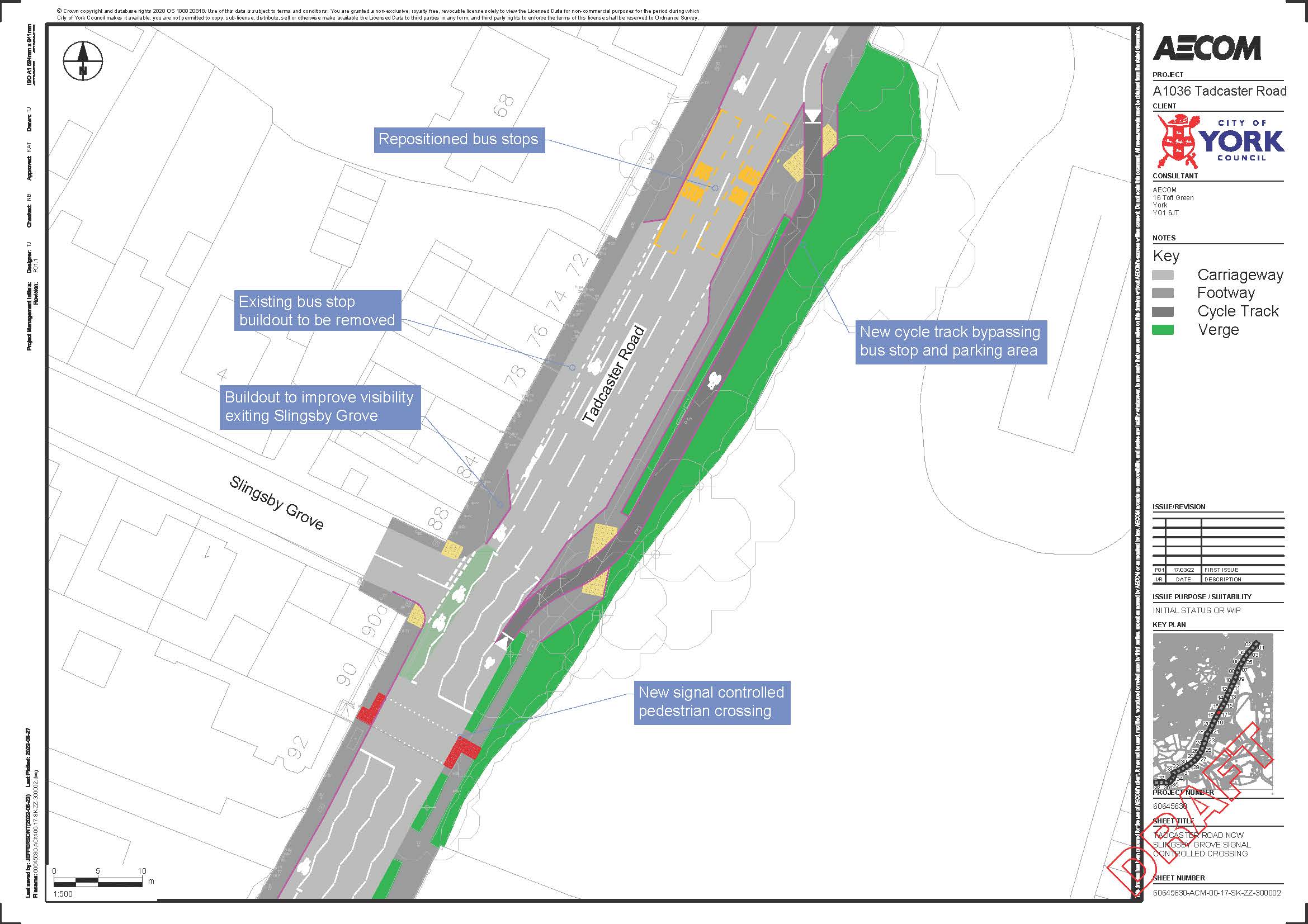
a new location for the pedestrian crossing to provide a safe place for people who park in the southbound layby, and for residents who live in the Hunters Way estate, to get to the shops, bus stop and beyond
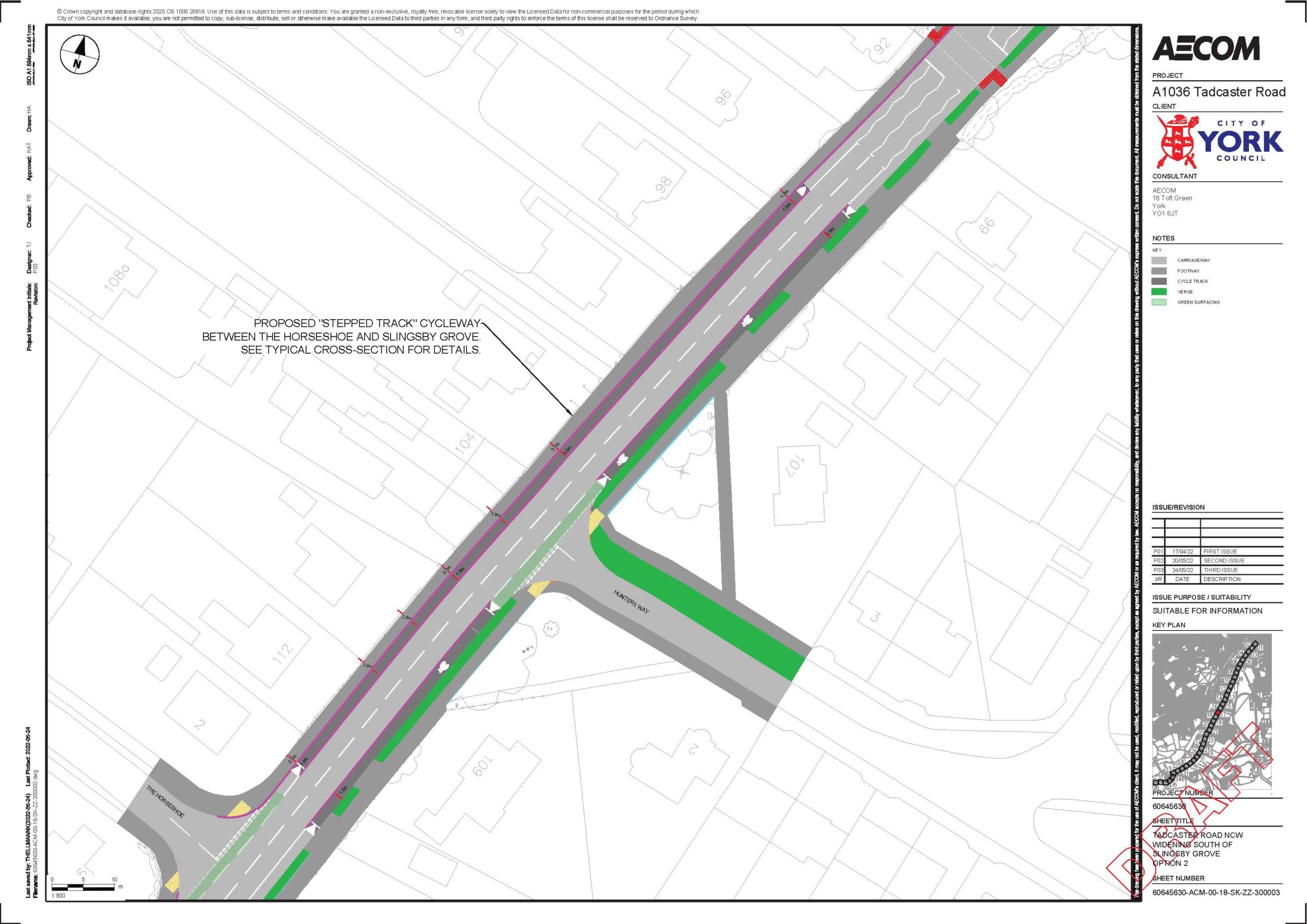
a stepped cycle track between The Horseshoe and Slingsby Grove. The cycle way would be higher than the road but lower than the footway, and is divided by a kerb, providing some protection for people cycling from motorised traffic
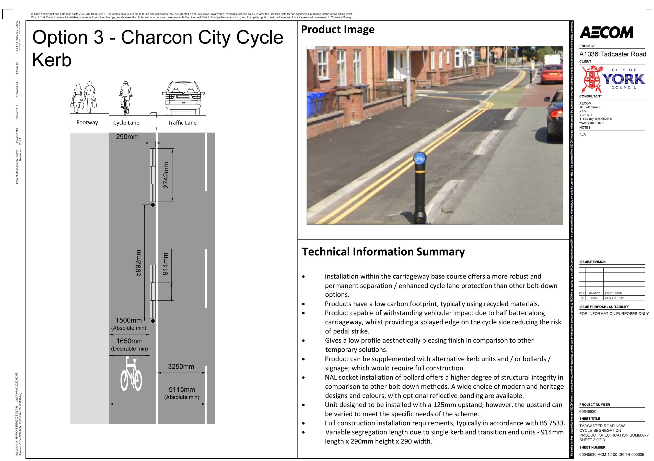
new cycle lane bollards at strategic locations along the route. These highly visible plastic bollards will clearly indicate the cycle lane, to help provide additional protection to people cycling from motorised traffic. The cycle lanes will also be surfaced green, across the mouth of side roads, to highlight their presence to other road users
The proposed works will be funded by £1.4m from the West Yorkshire Combined Authority. This is money that cannot be spent on general highway maintenance.
Erection of single storey extension extending 6.00 metres beyond the rear wall of the original house, with a height to the eaves of 2.40 metres and a total height of 3.90 metres
Certificate of lawfulness for proposed use of existing dwelling as a dwelling within use class C3(b) (those living together as a single household and receiving care)
Below are the latest planning applications received by the York Council for the Dringhouses and Woodthorpe ward.
Full details can be found by clicking the application reference
—–
54 Leeside York YO24 2PR
Erection of single storey extension extending 3 metres beyond the rear wall of the existing enlargement, with a total enlargement of 4.87 metres, height to the eaves of 2.64 metres and a total height of 3.6 metres
Below are the latest planning applications received by the York Council for the Dringhouses and Woodthorpe ward.
Full details can be found by clicking the application reference
—–
8 White House Gardens York YO24 1EA
Enlargement of dwellinghouse by construction of 1no. additional storey with new roof height no greater than 3.5 metres above the highest part of the existing roof under Town and Country Planning (General Permitted Development) (England) Order 2015 (as amended) – Schedule 2, Part 1, Class AA
Dringhouses & Woodthorpe ward councillors have welcomed the publication of further details of measures designed to support cycling, walking and bus use along the Tadcaster Road corridor and a commitment for further engagement with residents and modal groups on ‘light segregation’ proposals designed to improve cyclist safety.
These proposals will be considered at a public Executive Member for Transport Decision Session on Tuesday 18 January at 10am.
The report being discussed at the meeting is available HERE.
The proposed £1.4m scheme is funded from the West Yorkshire Combined Authority’s Transforming Cities Fund and will be delivered as part of a wider package of measures funded by the Department for Transport’s Local Highways Maintenance Challenge Fund. The £1.4m funding can only be used on measures to promote cycling, walking and bus use, and cannot be diverted into general highway maintenance.
The Tadcaster Road proposals have been informed by feedback from residents
The latest draft of the proposals take into account feedback from residents that was submitted during a consultation exercise held in August and September 2021, which informed revised proposals set out in a report to a Decision Session held in October 2021. The October report stated that work would be undertaken to explore options for ‘light segregation’ along sections of Tadcaster Road to offer cyclists better protection. It also committed to looking again at proposals to relocate an inbound bus stop near to Slingsby Grove and the positioning of a proposed new pedestrian crossing in that area, both of which had attracted comments and concerns in the consultation.
The report to be considered at the 18 January meeting contains further revised proposals – summarised below – which reflect feedback received and detailed design and costing work undertaken:
Widening of the footpath / cycle path at the corner of Tadcaster Road and Knavesmire Road.
Confirmation of the proposed pedestrian crossing near to the junction with Nelsons Lane.
The pedestrian crossing proposed for The Horseshoe area is to be moved to just south of Slingsby Grove (nearer to the shops), retaining a pedestrian refuge to cater for crossing movements near Middlethorpe Grove.
The proposal to relocate the inbound bus stop near Slingsby Grove 75 metres south has been dropped. Instead, it is proposed to retain the bus stop within the shopping area, placing it approximately 20 metres north of its current location. This would create a continuous parking / loading bay outside the shops and provide an opportunity to take steps to improve sight lines for vehicles turning right out of Slingsby Grove. The report commits to localised consultation with residents and businesses in the Slingsby Grove area about the proposed changes from the plans presented last year.
Work is to continue to identify measures to improve the very narrow shared cycle / foot path opposite the Sim Balk Lane junction – known as ‘cemetery corner’ – with funds set aside to accommodate a scheme at this location.
Some sections of ‘light segregation’ are proposed as a means to improve cyclist safety on the corridor. The report notes that a variety of different techniques are being used by different local authorities. It states that design options should be considered carefully to minimise maintenance and visual intrusion while protecting users in the lane.
The various constraints along Tadcaster Road are summarised in the report, and these mean it is not possible to provide segregation all the way along the corridor but it is proposed to use segregation (in the form of bolt-down ‘rails’) at a number of locations where cyclists are most vulnerable. It is also proposed to introduce some light segregation in the form of a ‘stepped cycle lane’ on a section of Tadcaster Road in the Hunters Way area, where the road is wide enough to accommodate this.
The report commits to further engagement to refine the approach to light segregation which is proposed and to identify and address any issues or concerns that may be raised. Local councillors will ensure that residents are kept informed and have the opportunity to raise any comments or concerns.