Big programme of highway resurfacing works announced for Dringhouses and Woodthorpe area

The York Council has announced which roads and footpaths will be resurfaced this year. The programme is the biggest for several years with, in total, £8,091,500 is due to be invested.

This represents an increase of 27% over the previous years budget

Around 100 individual roads are listed for resurfacing.

In the Dringhouses area, the programme includes £1/4 million for work on the following roads and footpaths

Bracken Road Carriageway Dringhouses £81,000
Middlethorpe Grove Carriageway Dringhouses £137,000
Little Hob Moor Cycle path Dringhouses £1,750
Acomb Wood Close Footpath Dringhouses £4,000
Alness Drive Footpath Dringhouses £27,000
Ashbourne Way Footpath Dringhouses £5,000
Deveron Way Footpath Dringhouses £14,000
North Lane Footpath Dringhouses £7,000
Old Moor Lane Footpath Dringhouses £7,120

The full list of streets which will receive attention can be viewed by clicking here

Prompt action on graffiti

Cllr Stephen Fenton reported to Network Rail recently two locations in the ward where graffiti ‘artists’ have been at work – at the Hob Moor underpass and on St Helens Road railway bridge – see pictures below.


We are pleased to report that Network Rail acted quickly and the graffiti was painted over on Tuesday 14 March.

We continue to press Virgin Media to take action to clean off graffiti on their cabinets on Chaloners Road, Wains Road and Lowick.

Concern at destruction of Tadcaster Road verges

Local Lib Dem councillor Stephen Fenton is taking action in response to residents’ concerns about the damage being done to the grass verges in front of 302 Tadcaster Road, the site of the former Knavesmire Manor Hotel.

tad-rd-verge

Mud bath

There is significant renovation work being done to the building, and a new property has been constructed to the rear, which is now on the market. The verges to the front of the former hotel have ben turned into a mud bath.

Stephen has asked council officers to take action that will lead to the verges being reinstated to their former state.

tad-rd-verge-for-sale-sign tad-rd-verge-sign

Vehicle monitored doing 68 mph in Alness Drive 20 mph zone

In response to a Freedom of Information request, the York Council has published updated figures indicating the effect that the revised 20 mph speed limits have had on average vehicle speeds and accident levels.

The figures reveal that the new limits have had little or no effect on average vehicle speeds while some accident levels have actually risen.

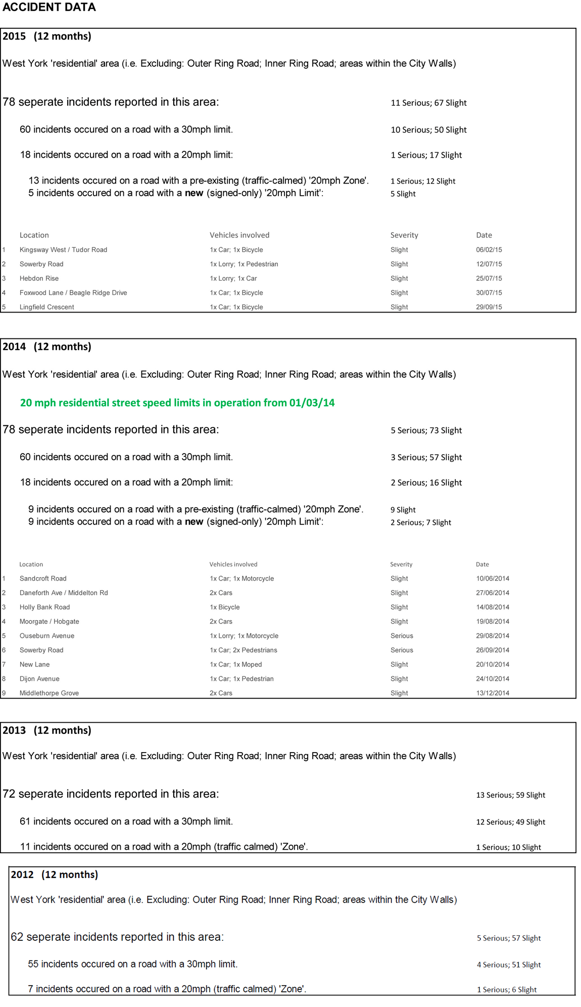
The data updates that published in March 2015 which showed similar results.

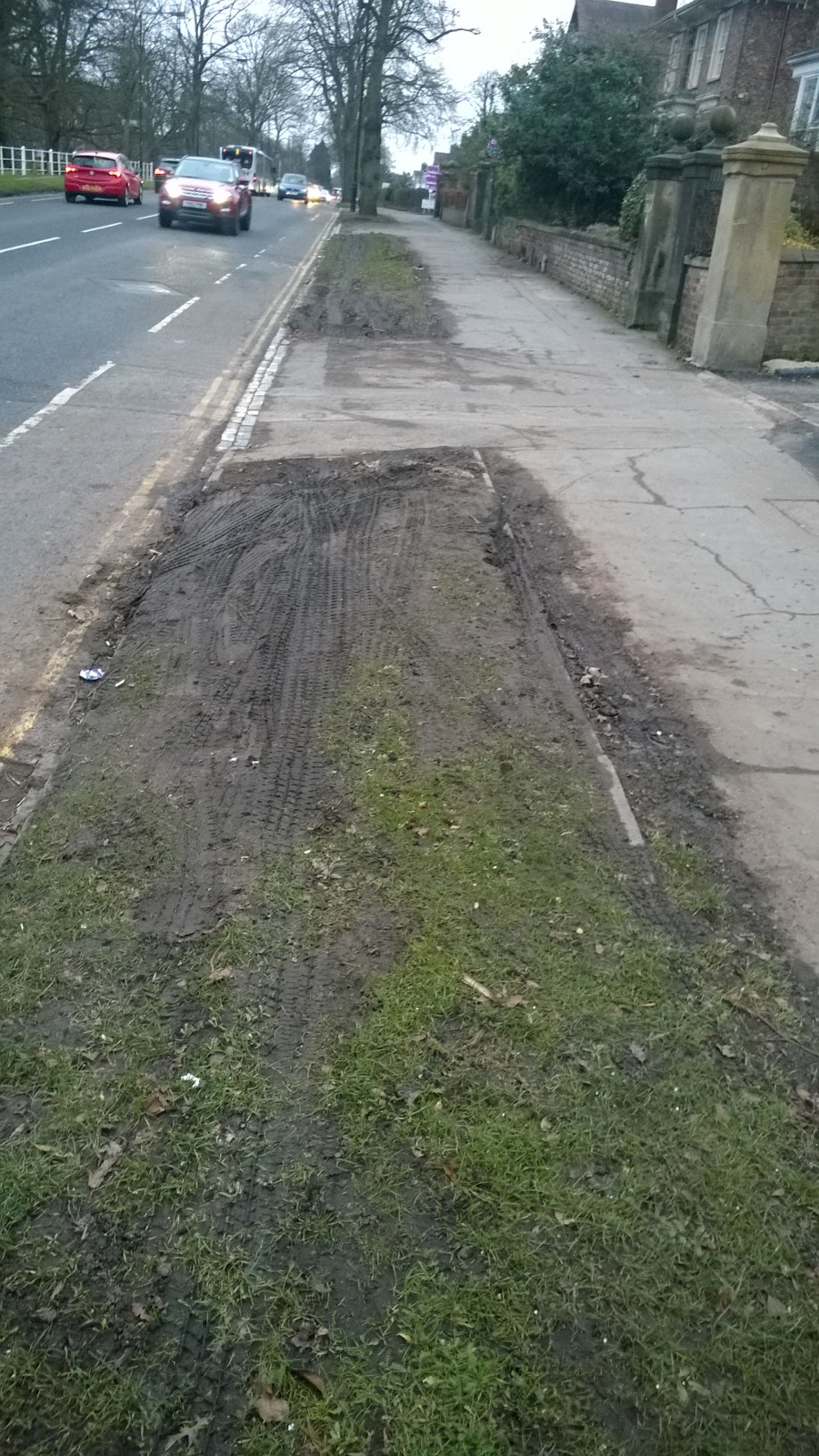
The data covers the 20 mph wide area limit in western York implemented in 2013/14. The project cost £600,000 to implement and was widely criticised for failing to recognise that such limits were unenforceable and, in any event, would have a negligible effect on accident levels.

Opponents wanted the money spent directly on safety improvements at accident black spots.

On some 20 mph roads such as Alness Drive the maximum speed recorded this year has been as much as 68mph – well above levels seen before the speed limit change

Overall there has been a reduction of only 1.3 mph in mean speeds.
Accident levels in the area have increased from 62 recorded in 2012 to 78 in 2015

On a related issue, North Yorkshire police are to be asked to justify their decision to increase the number of mobile speed enforcement cameras vans to six.

The Police responded to an FOI inquiry indicting that they only held information relating to the total number of offences which had been recorded when a van visited a particular location. This information had been published on their web site for couple of years now.

The police also publish how they they are dealing with specific speeding complaints raised by members of the public (although there is a backlog). click here

However, it doesn’t provide a measure of how effective the vans have been in controlling vehicle speeds or in reducing the number of accidents on the roads being monitored.

The number of drivers exceeding the prevailing speed limit is only a crude reflection of the “success” of the cameras.  Changes in offender numbers may simply reflected changes in traffic volumes.

Against a background of increasing numbers of road casualty’s, residents need to be convinced that roads are now safer as a result of police investment.

A further request for the information is now being drafted.

Comparative vehciels speeds in west York pre and post 20 mph limits

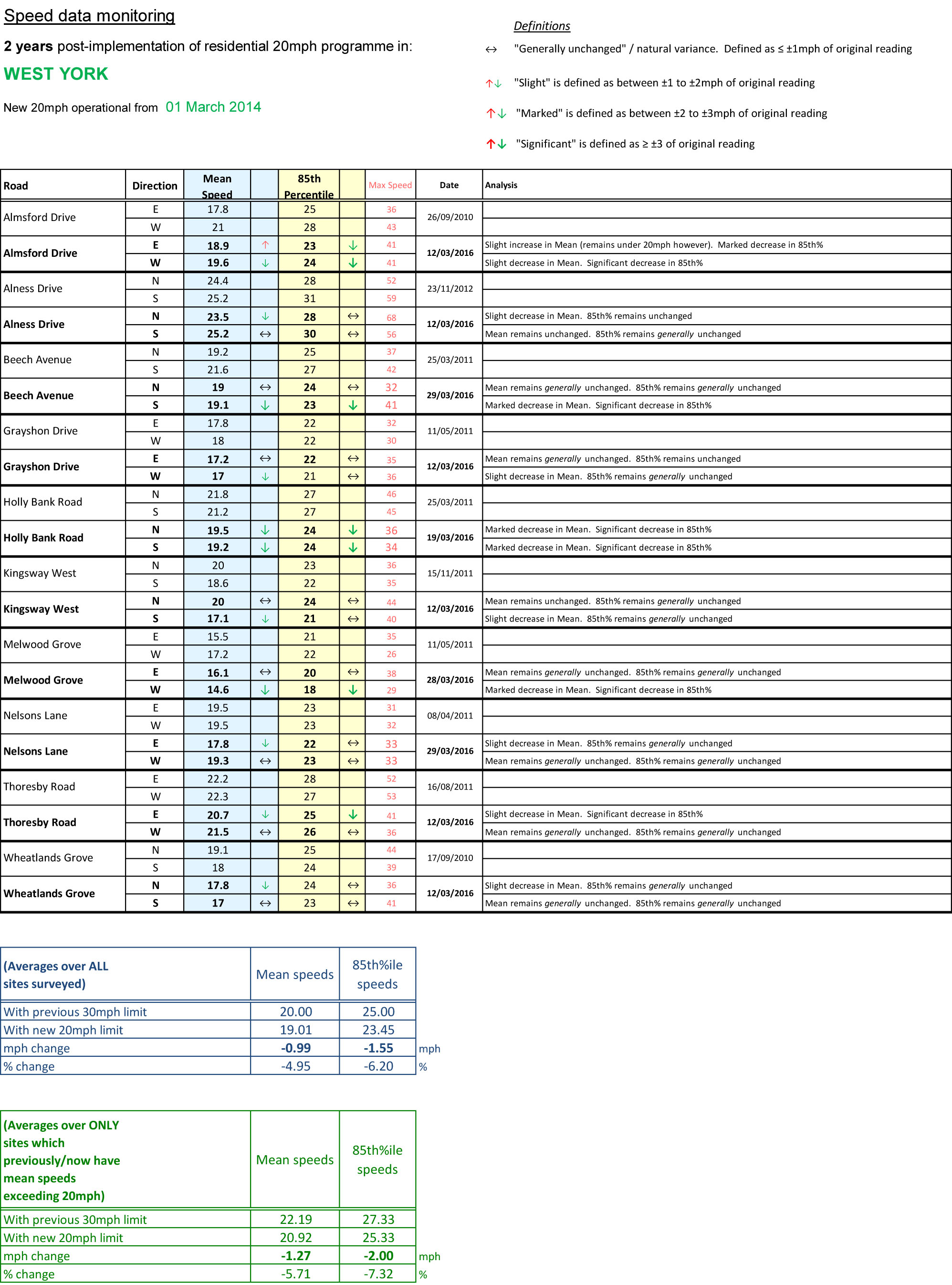
Comparative vehicle speeds in west York pre and post 20 mph limit change

Road accident trends in west York

Road accident trends in west York

Charges likely for fishing at Chapman’s Pond

Charges are to be introduced for people wishing to fish at Chapman’s Pond on Moor Lane.
Chapmans pond children fishing 1971

Chapman’s Pond 1971

The charges will be levied when the lease of the site, to the Friends of Chapman’s pond, is concluded later in the year.

The charges are expected to be £3 per day or £15 per year for adults, £1 a day or £5 a year for 13 – 16 years olds and free for under 12s. This level of charging is comparable with the nearby Railway Pond. Fishing has previously been free at the site.

Last year the pond had to be closed to anglers following an outbreak of disease in the fishing stock. At the suggestion of the Environment Agency, and with the support of the anglers, the Council closed the pond during this year’s spawning period resulting in a huge reduction in the number of fish deaths compared to last year

An anglers group is expected to appoint volunteer bailiffs to police fishing at the pond.

The move is also expected to address anti-social behaviour problems at the pond although it is not yet clear whether the boundary will be secured.

Chapman’s Pond is a 2.6 ha site off Moor Lane in Dringhouses. The pond itself covers roughly a third of the site with other habitats including woodland and meadow. It is currently managed by the Council with the assistance of the Friends of Chapman’s Pond.

The Friends are a long running group and have over the years carried out practical maintenance tasks and conservation enhancements. They have also assisted with fund raising, in particular for the circular path in 2011/12 and, for the last three years, in partnership with Love to Eat Café, a summer fair has taken place on site.

The area will be leased to the Friends for a nominal fee initially for three years.

The plan is being discussed at a Council meeting taking place on 23rd September.

Pothole blitz underway

We have reported a number of potholes across the ward that need filling in, most of which have now been logged for action by the council.

We are keen to get this work done before the winter frost and ice sets in, which tends to make already weak road surfaces even weaker and leads to further erosion. The potholes to be filled in are listed below. Others have reported and we await confirmation that they will be fixed also.

Pothole montage

There are a number of streets in the ward that are in desperate need of resurfacing or large patching, including West Thorpe, The Horseshoe and Hillcrest Gardens.


Local Plan consultation – have your say before Monday!

The council’s consultation on the draft Local Plan close at 5pm on Monday 12 September. We would urge all residents to have their say on the proposals, and in particular to support the proposal to designate land off Moor Lane as green belt land protected from development.

Extract from the 'Our City' newsletter

Extract from the ‘Our City’ newsletter


The Moor Lane site was referred to in previous drafts of the Local Plan as site ‘ST10’.

Information on how to take part can be found on the council website at http://york.gov.uk/localplan


Tidy-up needed at city entrance

We are calling for action to improve the appearance of one of the main southern entrances to the city.

Motorists coming off the A64 onto the A1036 Tadcaster Road are currently greeted by overgrown weeds on land around the new Askham Bar Park & Ride site. We have contacted City of York Council officers, and First York who operate the Park & Ride site, to try to get some action taken to make the area look more presentable.

Exit from the Park & Ride site

Exit from the Park & Ride site

Cyclists travelling into the city also face problems navigating bushes which are overhanging the path opposite the Sim Balk Lane junction.

Cycle path obstruction

Cycle path obstruction


We have also asked that weeds are removed from the ‘Welcome to York’ sign and flowerbed at that junction.