York College to take redundant Moor Lane car parking spaces

The Moor Lane Car Park (former Park & Ride site next to Tesco) is now a pay and display car park with 500 spaces run by the York Council.

With the larger and free park and ride site nearby, not surprisingly the car park is little used.

The Council has been approached by the Principal at York College to help facilitate their parking arrangements during the summer period while building works are undertaken on site.

Council officials have agreed that 50 spaces will be provided at a flat rate of £2 per day for use by York College during the period 7 July to 31 August 2014.

A review will take place at the end of this period.

Tadcaster Road has third highest number of speeders in York


Results from the mobile camera speed camera van, for the first 3 months of 2014, have revealed the roads on which the highest numbers of Penalty Charge Notices have been issued.

North Yorks speed camera van

A total of 747 tickets have been issued to drivers exceeding the 70 mph speed limit on the A64 southern by pass near Heslington and traveling in an eastbound direction.

527 PCNs were issued to drivers on the same section of road while traveling in a westerly direction.

The next highest numbers were on Tadcaster Road (85), Strensall Road, Huntington (52) and Dunnington Lodge (23)

A copy of the results, for the whole county, can be downloaded from here

Mobile safety camera routes week commencing 23 April 2014

Below are the enforcement locations for North Yorkshire Police’s mobile safety cameras for week commencing Wednesday 24 April 2014.

More

York Council publishes Local Plan objections

Largest ever response by residents and businesses

The scale of the opposition, to Labours plan to increase the size of the City by 25% over the next 15 years, is now apparent as all the objections registered have been published on the Councils web site.

It would take someone weeks to read through even the summaries which have been provided.

These include sections on the proposed Moor Lane development, land to the rear of The Square and at the stables on Tadcaster Road. Dozens of objections have been lodged including one from English Heritage.

In addition to individual responses 21 petitions were submitted by residents.

Some commentary has been provided by officials but it remains unclear when Councillors will get the opportunity to debate the issues raised and, indeed when objectors will get the chance to make representations in person prior to the next draft being published.

The draft plan has already been undermined by the revelation a few days ago that, over the last 18 months, most planning permissions in the City have been granted on brownfield sites not identified for housing development in the Draft Local Plan published last year.

Housing building sites – more information released

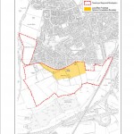
Moor Lane developers option - click to enlarge

Moor Lane developers option – click to enlarge

The York Council has released more details of the assessments that it has made of requests by landowners for particular sites to be considered for development.

They include assessments for some sites, which were rejected, and are not being considered at its meetings on the 17th April  and 23rd April 2014

Council officials have reviewed development boundaries at several sites put forward last year.

Council officials have agree to reduce the area of land available for house building to the rear of St Leonards Hospice (site 247). This is aimed a preserving the views for patients. However officers continue to endorse building on the farm land to the rear of The Square. The housing site further down Tadcaster Road site 696) at the stables will not be increased in size.
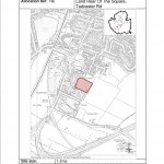
Hospice/The Square site. Click to enlarge

Hospice/The Square site. Click to enlarge

A proposal by developers to more than double the size of the Moor Lane site (ref ST10) – itself highly controversial – has also been rejected by officials

They are relevant though in so far as they provide an indication of the landowner’s development aspirations. They are likely to reappear at the Public Inquiry later in the year when owners will try to have additional development land added to the Plan.

39 sites, including one off Askham Lane, were rejected because they failed to respect the natural environment; two were rejected because they were on open space, while 21 had poor transport links and/or access to services
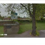
Stables housing site on Tadcaster Road

Stables housing site on Tadcaster Road

The proposals included the land (site ref 220) on Wetherby Road – near Knapton – originally suggested as a “Showman’s Yard” site. Now the owners want to build housing there. Worryingly the reason given by the Council officials for opposing development is the “lack of public transport”. No mention is made of its green belt credentials.

26 sites failed a “technical evaluation”. These included land to the west of Chapelfields (ref 778) which was rejected on grounds of landscape value and potential archaeology.
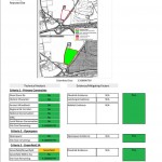
Askham Bryan transhipment depot plan. Click to enlarge

Askham Bryan transhipment depot plan. Click to enlarge

There is a similar list of changes to sites proposed for Employment/Retail use.

These include a “freight transhipment” and Compressed Natural Gas (CNG) site on land between the A1237 and Askham Bryan. Although currently well screened by trees, this is an elevated site which would be visible from several miles.

Officials also rule out the development of even more of the open space between Woodthorpe, Foxwood, Chapelfields and the ring roads (site 791) and the rest of Acomb Moor (site 792) although the partial development of the moor still remains part of the draft Plan.

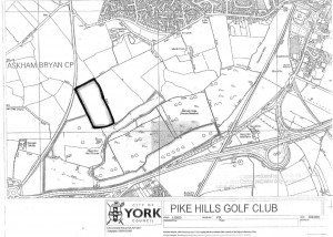
Pike Hills golf club to expand?

Click for larger map

Click for larger map

The Golf Club on Tadcaster Road is seeking planning permission to extend the size of their course

In total around 7.7 acres of agricultural land would be used to extend the course if planning permission is granted on 20th March

Planning permission was granted in 2004 for a similar scheme but the permission was not implemented.

The scheme does not propose the erection of any additional buildings and would not increase the number of holes on site.

The extension would allow for the existing course to be reconfigured to allow for longer holes and to prevent holes from crossing each other.

The land is currently cultivated and is classified as being Grade 3a agricultural land (good).

The site lies to the north of the existing golf course and abuts the A1237 for a short distance.

The site is very flat in nature and is bounded by hedging and a number of mature trees which are to be retained.

Tour de France – Tadcaster Road parking arrangements revealed.

The Council has now announced two further campsites on its web site.

They will be at Millennium Bridge and the Designer outlet.
Tour De France finish
Again no consultation has taken place with affected residents and the information has yet to appear on the official TdF website

Official “all day” car parking is being offered at the “old” Askham Bar Park and Ride site for £8. By June this car park will have closed as the new adjacent site will have been brought into use. People will be expected to walk from there to the Knavesmire.

Behind closed doors logo

Mystery also surrounds the costs of repairing highways on the TdF route. No provision has been made in the Councils budget for essential repairs although the whole of the highways network is in increasing need of major investment.

All decisions on the organisation of the TdF locally are being taken behind closed doors.